


Egretry Flightline Surveys: towards a standardised methodology
Abstract
Land supply for development in Hong Kong Special Administrative Region (SAR) is at a premium. Sites best-suited for building are in lowland areas close to wetlands where there are potential conflicts between development and breeding ardeids. Large scale developments are required to undergo an Environmental Impact Assessment (EIA) in Hong Kong. Egretry Flightline Surveys are sometimes conducted to assess impacts to either the flightlines of breeding birds and/or their foraging habitats. There is no standardised methodology for undertaking such surveys in Hong Kong, or elsewhere. Here we review 10 EIA reports and the Egretry Flightline Surveys conducted as part of this process in Hong Kong, supplemented by our own findings and observations on active egretries in the Mai Po Inner Deep Bay Ramsar Site. This paper has been prepared to provide guidance for EIA practitioners and conservationists alike in developing flightline surveys and outlining the factors that need to be considered. We provide a short glossary to allow consistency with terminology.
Key words: Chinese Pond Heron; egretry; Environmental Impact Assessment (EIA); flightline; Hong Kong; Little Egret; methodology.
Introduction
In the Hong Kong Special Administrative Region (SAR), Egretry Flightline Surveys (hereafter ‘flightline surveys’) are an important tool in investigating the foraging grounds used collectively by birds breeding at an egretry (or resident at non-breeding roost sites) and also the airspace utilised when accessing those areas; understanding both may be essential to the long-term protection of an egretry. However, there remains no standardised methodology for undertaking such surveys in Hong Kong, or elsewhere.
A flightline is defined here as a route which is regularly followed for local movements of multiple individual birds (unlike a flight path, which is the route of a single flying bird on a single occasion, or a flyway which is a broad route followed by a large number of migrating individuals over a long distance). An egretry flightline therefore refers to the route taken from the egretry to foraging areas by egrets. Geographical features may influence the location of flightlines; for example, ardeids tend to follow water features such as rivers and may follow valleys even when a route crossing a line of hills would be shorter (Ove Arup and Partners Ltd. 2013a).
In Hong Kong, flightline studies have been used to identify preferred foraging areas of breeding ardeids (Wong 1991, Young 1993, Smith 1995, Wong et al. 1999, 2001, Kwok and Dahmer 2002, Wong and Young 2009). Elsewhere, flightline surveys of colonial waterbirds are implemented as a census technique at nesting colonies (Erwin 1981, Jones 2008) or to investigate habitat use (Custer and Osborn 1978, Pratt 1980, Erwin 1983, 1984, Hafner and Britton 1983, Maccarone and Parsons 1988, Smith 1995, Wong 2002).
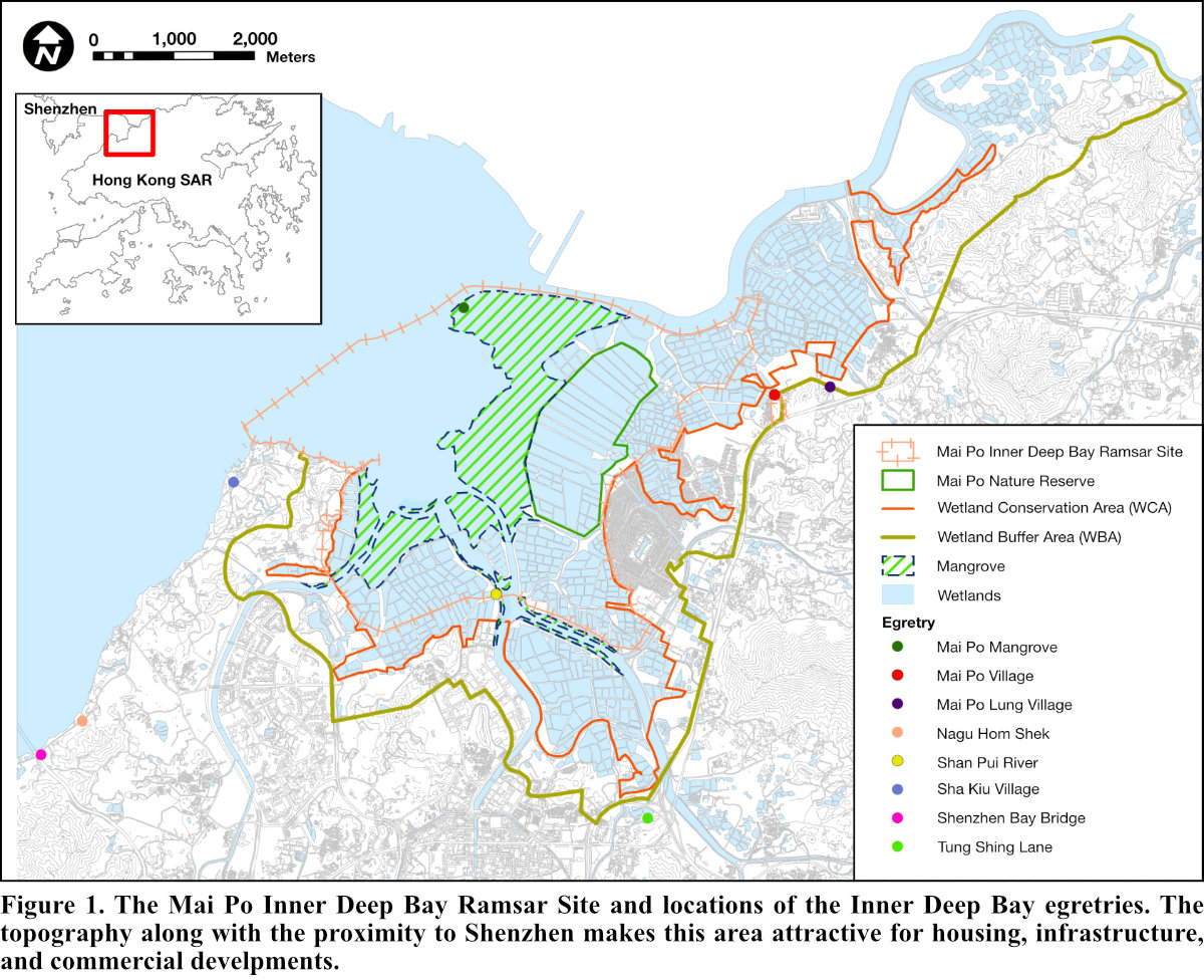
As part of the statutory Hong Kong Environmental Impact Assessment (EIA) process, flightline surveys may be conducted to assess impacts of proposed developments close to egretries. There is much pressure for development of lowland habitats of Hong Kong; these areas are often lower elevations, where topography is more conducive to development and often have transport linkages to neighbouring Shenzhen and the Greater Bay Area. The 1,500 ha wetland mosaic that forms the Mai Po Inner Deep Bay Ramsar Site, is in close proximity to many of these potential developable areas and as a result, there are conflicts between egretries and increased urbanisation (see Fig. 1). Whilst these wetlands are afforded some protection through the Wetland Conservation Area, there is increasing pressure to develop the Wetland Buffer Areas. In 2020, there were eight recognised egretries in the Inner Deep Bay area, ranging in size from three to 757 nests (Anon. 2021).
Whilst guidelines have been produced for construction work near egretries by The Hong Kong Birdwatching Society (2016), the only recommendation with respect to flightlines in this document is that ‘flight line [sic.] of egrets and herons between the roost and their foraging ground should not be blocked by the construction works, construction materials, machineries or any temporary structures’ with no further elaboration. There are currently no protocols or guidelines in place for flightline studies for breeding, or non-breeding, ardeids in Hong Kong.
This paper has been prepared to summarise previous flightline studies in Hong Kong and to provide guidance to practitioners in developing flightline surveys and the factors that need to be considered, not just in Hong Kong but also so they can be adapted and implemented elsewhere and for other colonial waterbird species. Here we have focused on flightlines of ardeids departing from breeding sites to foraging habitat, taken from previous EIA reports supplemented with findings from our own observations.
Methods
A literature review was undertaken investigating the use of flightlines by breeding ardeids. Hong Kong has an open EIA process and numerous EIA studies have been published for proposed developments in lowland Hong Kong that potentially affect breeding ardeids. Accordingly, a comprehensive review was undertaken of EIA reports available at the Environmental Protection Department website (https://www.epd.gov.hk/eia/).
EIA reports provide various graphical presentations to demonstrate the results of flightline surveys and to inform the assessment of the potential impacts of a particular development. For this study, we created a hypothetical egretry in Hong Kong’s northwest New Territories (the Mai Po Inner Deep Bay area) and overlaid the actual survey data from a separate study using the various styles of figures typically employed for EIAs. By standardising the data and egretry location, a better comparison of presentation methods can be ascertained.
Results
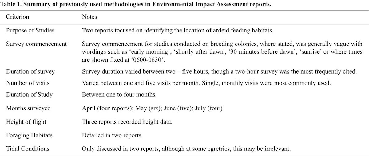
Of 136 EIA reports published between 2002 and 2020, 10 included egretry flightline surveys. It was notable that each survey differed in its methodology and did not follow any set guidance or precedents. Two additional EIAs presented findings of flightlines studies for all birds, not with a specific focus on breeding ardeids (AECOM 2009, Ove Arup and Partners Ltd 2013b); these EIAs are not considered in this review. A summary of the 10 EIAs referred to in this paper is detailed in Table 1.
Presentation of Findings
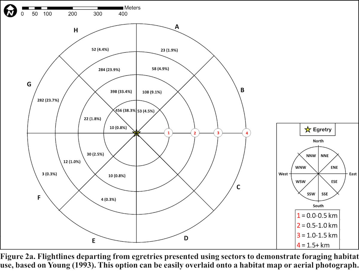
Graphical and visual presentation of flightlines was variable throughout all the EIA studies; however, these may need to be specific to particular projects. Examples of data presentation styles of flightline studies from published Environmental Impact Assessments can be seen in Figures 2a, 2b, 2c, 2d, 2e, 2f and 2g.
One of the EIA studies presented flightlines departing egretries by sectors to demonstrate foraging habitat use, based on Young (1993). This is represented in Figure 2a. This option can be easily overlaid onto a habitat map or aerial photograph.
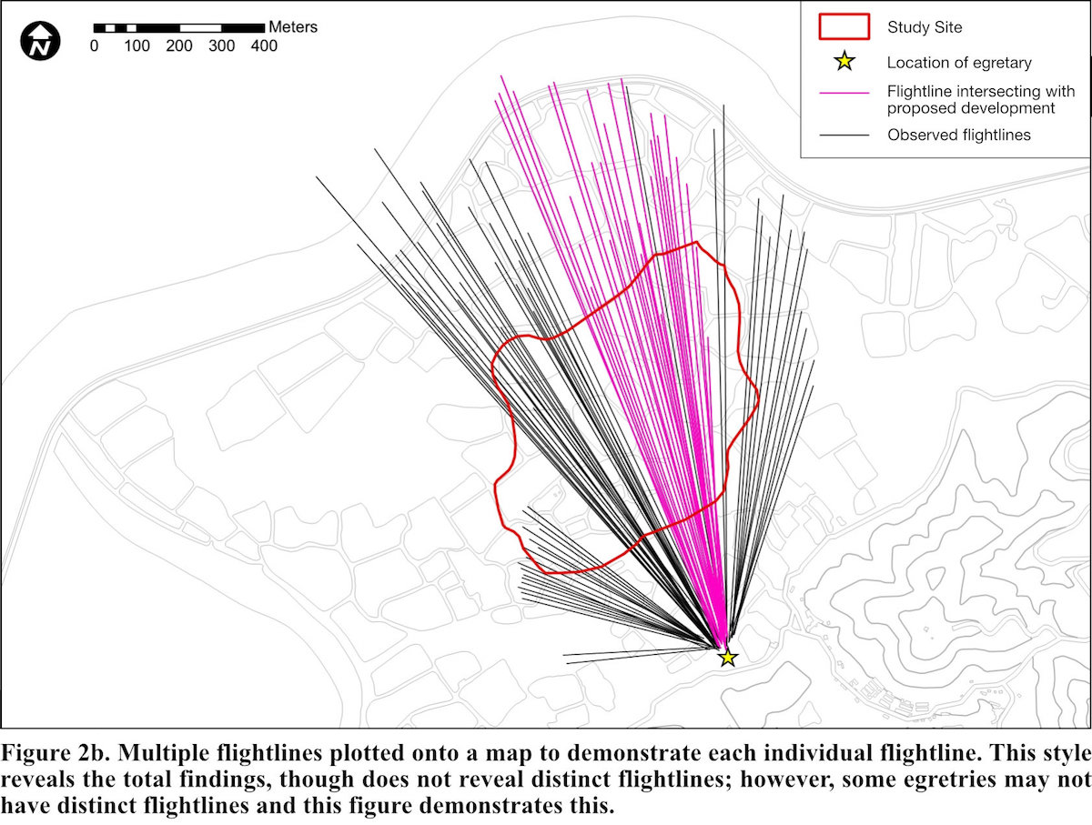
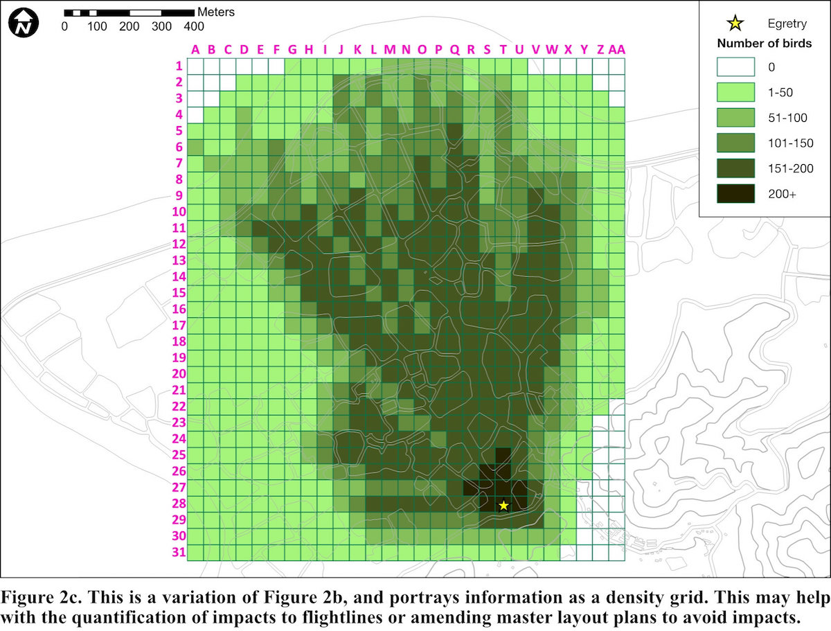
Multiple flightlines were plotted onto a map to demonstrate each individual flightline (Fig. 2b). Whilst this reveals the total findings, this is can be confusing and does not reveal distinct flightlines; however, some egretries may not have distinct flightlines and this figure demonstrates this. Figure 2c is a variation on this and perhaps allows the quantification of impacts.
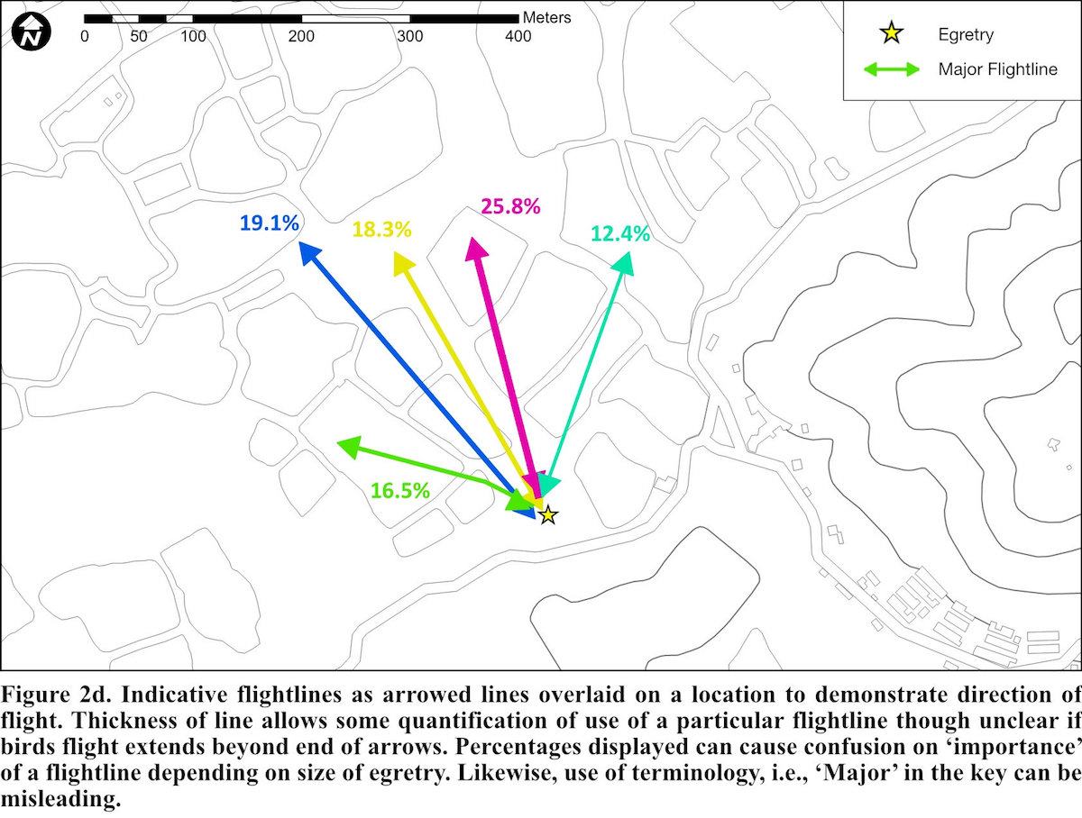
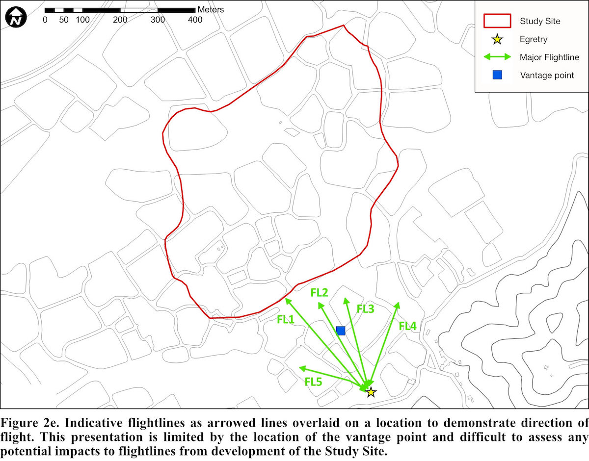
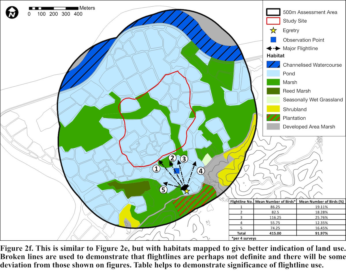
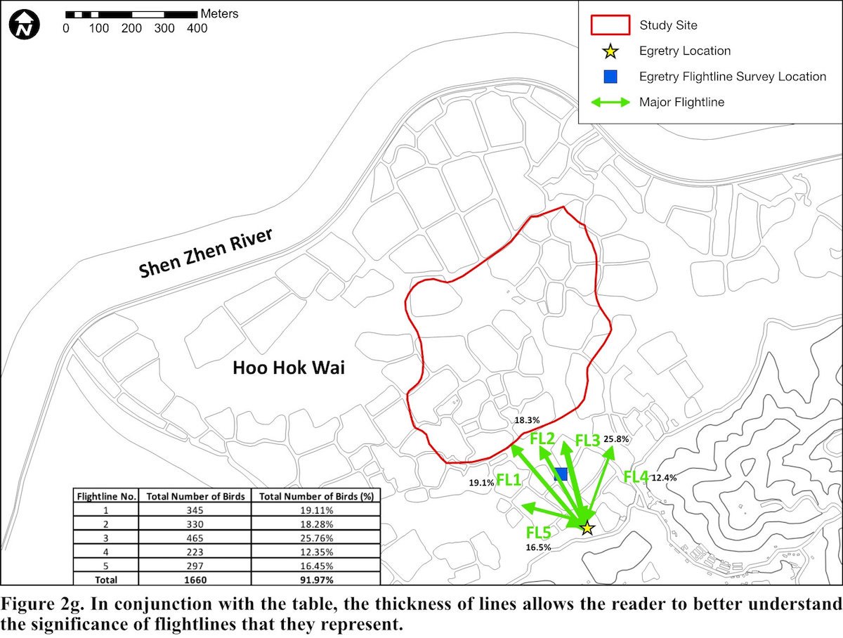
Most EIA studies produced figures that display indicative flightlines as arrowed lines (Figs. 2d, 2e, 2f and 2g), overlaid on a location or habitat map to demonstrate direction of flight. In some figures, the thickness of lines represented the proportion of flightlines they represent (Figs. 2d and 2g). Broken lines were used to demonstrate that flightlines are perhaps not definite and there will be some deviation from those shown on figures (Fig. 2f).
Recommended approach to flightline surveys
Field Methods
In theory, the methodology for conducting a flightline survey is simple; an observer or observers, based at a suitable vantage point(s), will observe ardeids as they depart an egretry, presumably to preferred foraging areas. The species, direction of flight, landing point and flying height should all be recorded as a minimum. Wong et al. (2001) suggest that a census technique is more efficient for assessing the use of habitats while suggesting flightlines are best used to investigate overall use of a landscape during the breeding season, though they do not provide a detailed methodology (from Wong et al. 1999) in how to undertake such a census.
Criteria employed in other flightline studies are listed in Table 1, though these are inconsistent. To develop a standardised methodology for flightline surveys, we propose the following criteria that should be considered by the surveyor.
1. Timing of individual surveys
Whilst flightline surveys can be conducted throughout the day, this is often not practical, and in our experience unnecessary in that surveys that focus on peak periods of activity can capture sufficient data for the purpose of study. It is generally accepted that the period of peak activity of birds departing from an egretry, a nocturnal roost or waterbird colony is significantly higher in the early morning (Young 1993).
Previous studies have shown that for Little Egrets, (Egretta garzetta), and Chinese Pond Heron, (Ardeola bacchus), departure times peak during the 30 minutes prior to sunrise and a steady decrease in departure activity thereafter (aec Ltd., unpubl. data). The peak departure time will vary with the species.
In a Hong Kong context, it is recommended that surveys should commence at least 30 minutes prior to sunrise and should last for a minimum of two hours; researchers could obtain more data more efficiently before sunrise. Larger colonies (i.e., more than 50 breeding pairs) may require a longer survey, more individual surveys (see below) or more surveyors.
2. Survey duration
Surveys aim to capture data on foraging departures; however, the timing of the breeding season varies according to species. There can also be differences between the timing of breeding within the same region. For example, breeding activity of an egretry in neighbouring Macau (some 40 km west across the Pearl River Delta) commences earlier in the year than those in Hong Kong (aec Ltd., unpubl. data). To compensate for this, regular surveys of the egretry will be required to inform when surveys should commence.
In Hong Kong, the peak foraging departures for Chinese Pond Heron and Little Egret are in mid-late June but do extend into July (aec Ltd., unpubl. data). Ideally such surveys are recommended from late March until mid-July and should be conducted at least twice per-month until mid-July. However, the frequency can be adjusted for the nature of the study and resources available. More regular survey visits would allow for any variation in feeding habits during different stages of the breeding cycle and may be better suited for more scientific research and behavioural studies.
3. Species composition of breeding site
Our study has focused on Chinese Pond Heron and Little Egret. Should other colonially-nesting ardeid species be recorded at the egretries, e.g., Eastern Cattle Egrets (Bubulcus coromandus) and Black-crowned Night Heron (Nycticorax nycticorax) in a Hong Kong context, the survey methodology would need further refinement. Eastern Cattle Egrets may have low, early morning flight frequencies as this may reflect low abundance of invertebrates, their food source, at that time of day (Maccarone and Parsons 1988); surveys may need to commence later in the morning. Likewise, egretries supporting Black-crowned Night Heron, a crepuscular and nocturnal feeder, would require adjustment to capture their departure times though there may be difficulties in properly assessing distance and/or direction depending on departure times and levels of light.
4. Vantage point
Finding a suitable vantage point is often the most problematic issue when undertaking flightline surveys. Ideally, the vantage point is such that the entire egretry and all potential foraging areas are in view (Erwin 1981, Young 1993, Wong et al. 2001, Jones 2008). In reality, this is rarely possible given the topography, tree coverage, buildings, distance to the feeding area or the extent of the egretry. Furthermore, in Hong Kong, Little Egrets and Chinese Pond Heron can range as far as 5.5 km (Anon. 2009) and 3.3 km (Wong et al. 2001), respectively, from the egretry making the ideal vantage point the exception rather than the rule. It is desirable to have up to three surveyors, each strategically located during each survey. The number and location of these will depend on the aims of the survey and size of egretry.
5. Height of flight
Recording flying height is especially important when dealing with the potential impacts of a proposed development and may be less important in other types of studies. Flying height is difficult to ascertain by naked eye and is best recorded relative to nearby features, e.g., buildings, pylons and trees for which the height can be accurately measured or is known. The use of a drone may help in measuring such features more accurately. Flying height will also vary with distance away from the egretry (especially if the egretry is at a higher elevation than the surrounding area) or if there is undulating topography. In such cases, height should be measured in the area where there is the potential for any impacts, or at a consistent point (e.g., when crossing a watercourse or road).
6. Tidal conditions
In marine areas, the state of the tide can have a profound effect on the foraging areas utilised (McNeil et al. 1993, Wong and Young 2009). Tide levels should be an important consideration in coastal sites where surveys should be conducted at different stages of the tides, covering at least the very low and very high tides. This may require more survey events to ensure sufficient data are collected at different stages of the tide.
Data presentation and points to consider
Presentation of flightlines is dependent on what the purpose of the study is. It is difficult to select any format or style (see Figs. 2a, 2b, 2c, 2d, 2e, 2f and 2g) which cannot be misconstrued or misunderstood by the layperson. Graphically presenting too much detail can obscure the flightline(s). Conversely, too little information may unwittingly increase the ‘importance’ of a flightline to the untrained eye.
The limitation with arrowed lines is that they are indicative only and do not allow for total distance flown. Likewise, it is not clear if the arrowed lines stop at the foraging area or if they just point in the direction of the birds’ flights and end at some undesignated point, beyond the sight of the observer. In this respect, fixed lines or arrows can be misleading, especially to the layperson, as once a line is drawn on a map, even if labelled as ‘indicative’ or ‘approximate’ as there is a tendency for the reader to take these lines as fixed and that there will be no deviation from these. Thickness of lines may distort the laypersons perspective of ‘importance’ of a flightline.
The surveyor is left to make their own choices on suitability of data presentation for their purposes of their study.
Discussion
There is little literature available from elsewhere in the world regarding flightlines studies for breeding/roosting ardeids. The EIA system in Hong Kong has been recognised as one of the best in the world in making all the EIA reports available to the public through a dedicated website (Kilburn 2009) and greatly aids this type of review.
Developments located on a flightline may result in a decrease in the suitability of a foraging, breeding or roosting site by preventing movement to another site or by reducing the efficiency of movement between sites. Any disruption to these flightlines may reduce foraging efficiency, leading to a reduction in survival or productivity (Mott Connell Ltd. 2008, Ove Arup and Partners Ltd 2013b). Whilst distances foraging birds fly varies with the location of egretry and the nature of the surrounding habitats, impeding flightlines through development may increase distances travelled and therefore increase energy expenditure; minor deviations to flightlines are considered negligible (Masden et al. 2010, Ove Arup and Partners Ltd 2017). Where impacts have been deemed significant enough for mitigation to be proposed, this has been achieved by way of avoidance through the adjustment of master layout plans to maintain corridors for birds to travel to and from foraging grounds (locally known as NBA – No Build Areas). These corridors may be up to 100 m in width.
It has been suggested that there may also be an increased risk of mortality by collision with structures constructed on or close to a flightline (Ove Arup and Partners Ltd 2013a). This is highly unlikely due to speed, and style, of flight of these species (Stanton and Klick 2018).
Care needs to be taken when proposing surveys across several years, as egretries can be dynamic, with locations changing over time or even abandoned (CH2M HILL Hong Kong Limited 2008, Ove Arup and Partners Ltd 2013a, Ove Arup and Partners Ltd 2017). Even egretries in protected areas with no or limited human disturbance can suddenly relocate for reasons not fully understood by researchers, e.g., Mai Po Nature Reserve (Anon. 2017).
It should be remembered that the effort required for flightline surveys may be limited by external factors. For example, weekly surveys may be ideal and provide a more comprehensive data set but there may not be sufficient funding available for this or conversely this may be limited by observer availability (pre-dawn surveys over an extended period of time may not be possible). The effort must be ‘fit for purpose’ for the study.
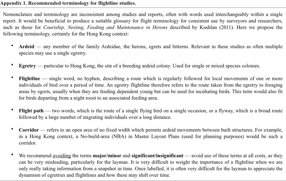
Flightline surveys can never be completely standardised as local conditions will need to be accommodated. Likewise, presentation of findings will need to be designed for each specific study and may be subject to the researcher’s personal preference or dictated by the intended audience. Nomenclature and terminology should be consistent among studies and we recommend specific terminology and points to consider in Appendix 1.
Acknowledgements
We would like to thank Jenny Hui and Moses Ma for help with preparation of data, graphics and figures, as well as Ms Ivy SO Wai-yan, Ivy of Agriculture, Fisheries and Conservation Department for help in sourcing some research documents.
Literature Cited
AECOM. 2009. Agreement No. CE 52/2007 (HY) Tuen Mun – Chek Lap Kok Link – Investigation. Environmental Impact Assessment Report to Hong Kong Special Administrative Region. [online] Accessed 27 July 2021.
Anon. 2009. Study of feeding habitats and foraging flightlines of ardeids colonies in Hong Kong. Report by Hong Kong Birdwatching Society to the Agriculture, Fisheries and Conservation Department, Hong Kong Special Administrative Region Government. Contact: Agriculture, Fisheries and Conservation Department, 5/F, Cheung Sha Wan Government Offices, 303 Cheung Sha Wan Road, Kowloon or .
Anon. 2017. Summer 2017 Report: Egretry counts in Hong Kong with particular reference to the Mai Po Inner Deep Bay Ramsar site. Report by Hong Kong Birdwatching Society to the Agriculture, Fisheries and Conservation Department, Hong Kong Special Administrative Region Government. [online] Accessed 27 July 2021.
Anon. 2021. Summer 2020 Report: Egretry counts in Hong Kong with particular reference to the Mai Po Inner Deep Bay Ramsar site. Report by Hong Kong Birdwatching Society to the Agriculture, Fisheries and Conservation Department, Hong Kong Special Administrative Region Government. [online] Accessed 27 July 2021.
CH2M HILL Hong Kong Limited. 2008. Proposed Development at Fung Lok Wai, Yuen Long Lot 1457 R. P. in D. D. 123. Environmental Impact Assessment Report to Hong Kong Special Administrative Region. [online] Accessed 27 July 2021.
Custer, T. W. and R. G. Osborn. 1978. Feeding habitat use by colonially-breeding herons, egrets and ibises in North Carolina. Auk 95: 733-743.
Erwin, R. M. 1981. Censusing wading bird colonies: an update on the “flight-line” count method. Colonial Waterbirds 4: 91-95.
Erwin, R. M. 1983. Feeding habitats of nesting wading birds: spatial use and social influences. Auk 100: 960-970.
Erwin, R. M. 1984. Feeding flights of nesting wading birds at a Virginia colony. Colonial Waterbirds 7: 74-79.
Hafner, H. and R. H. Britton. 1983. Changes of foraging sites by nesting Little Egrets (Egretta garzetta L.) in relation to food supply. Colonial Waterbirds 6: 24-30.
Hong Kong Birdwatching Society. 2016. Guidelines for planning and carrying out construction works at egretries. [online] Accessed 27 July 2021.
Jones, S. L. 2008. Western colonial waterbird survey protocols. Unpublished report, U.S. Department of the Interior, Fish and Wildlife Service, Nongame Migratory Birds Coordinator’s Office, Denver, Colorado. U.S.A. [online] Accessed 27 July 2021.
Kilburn, M. 2009. Conservation of birds in Hong Kong. Pp. 167-189 in L. C. Wong, V. M. Y Lam and G. W. J. Ades, eds. Ecology of the birds of Hong Kong. Hong Kong Special Administrative Region: Kadoorie Farm and Botanic Gardens, Hong Kong.
Kushlan, J. A. 2011. The terminology of courtship, nesting, feeding and maintenance in herons. [online] Accessed 27 July 2021.
Kwok, H. K. and T. D. Dahmer. 2002. Habitat utilization by Little Egrets Egretta garzetta breeding at Tai O egretry. Memoirs of the Hong Kong Natural History Society 25: 95-103.
Maccarone, A. D. and K. C. Parsons. 1988. Differences in flight patterns among nesting ibises and egrets. Colonial Waterbirds 11: 67-71.
Masden, E. A., D. T. Haydon, A. D. Fox and R. W. Furness. 2010. Barriers to movement: modelling energetic costs of avoiding marine wind farms amongst breeding seabirds. Marine Pollution Bulletin 60: 1085-1091.
McNeil, R., R. Benoît and J. L. DesGranges. 1993. Daytime and nighttime activity at a breeding colony of Great Blue Herons in a non tidal environment. Canadian Journal of Zoology 71: 1075-1078.
Mott Connell Ltd. 2008. Proposed comprehensive development at Wo Shang Wai, Yuen Long. Environmental Impact Assessment Report to Hong Kong Special Administrative Region. [online] Accessed 27 July 2021.
Ove Arup and Partners Ltd. 2013a. Northeast New Territories New Development Areas. Environmental Impact Assessment Report to Hong Kong Special Administrative Region. [online] Accessed 27 July 2021.
Ove Arup and Partners Ltd. 2013b. Lok Ma Chau Loop development. Environmental Impact Assessment Report to Hong Kong Special Administrative Region. [online] Accessed 27 July 2021.
Ove Arup and Partners Ltd. 2017. Yuen Long South Development. Environmental Impact Assessment Report to Hong Kong Special Administrative Region. [online] Accessed 27 July 2021.
Pratt, H. M. 1980. Direction and timing of Great Blue Heron foraging flights from a California colony: implications for social facilitation of food finding. Wilson Bulletin 92: 489-496.
Smith, J. P. 1995. Foraging flights and habitat use of nesting wading birds (Ciconiiformes) at Lake Okeechokee, Florida. Colonial Waterbirds 18: 139-158.
Stanton, D. J and B. Klick. 2018. Flight modifications as a response to traffic by night-roosting egrets crossing a road bridge in Hong Kong. Journal of Heron Biology and Conservation 3(4). [online] Accessed 27 July 2021.
Wong, F. K. O. 1991. Habitat utilization by Little Egrets breeding at Mai Po. Hong Kong Bird Report 1994: 196-215.
Wong, L. C. 2002. Pilot study: Feeding habitat use and foraging flights of ardeid nesting in the Mai Po Inner Deep Bay Ramsar site, Hong Kong - Waterbird monitoring at the Mai Po and Inner Deep Bay Ramsar site. The Hong Kong Bird Watching Society, Hong Kong.
Wong, L. C., R. T. Corlett, L. Young and J. S. Y. Lee. 1999. Foraging flights of nestling egrets and herons at a Hong Kong egretry, South China. Waterbirds 22: 424-434.
Wong, L. C., R. T. Corlett, L. Young and J. S. Y. Lee. 2001. Utilization of wetlands by ardeids in Starling Inlet, Hong Kong: a year-round study and a comparison between the census and flight-line methods. Waterbirds 24: 153-160.
Wong, L. C. and L. Young. 2009. Coastal Wetlands. Pp. 25-16 in L. C. Wong, V. M. Y. Lam and G. W. J. Ades, eds. Ecology of the birds of Hong Kong. Hong Kong Special Administrative Region: Kadoorie Farm and Botanic Gardens, Hong Kong.
Young, L. 1993. The ecology of Hong Kong Ardeidae (Aves) with special reference to the Chinese Pond Heron at the Mai Po Marshes Nature Reserve. PhD. Thesis, University of Hong Kong, Hong Kong.